Español

The recorded square footage of all 240 Oceana Bal Harbour apartments

Four figures exist for every apartment in this building: the area recorded in the declaration, the area the county carries, and the residence and terrace areas the developer published. This page sets all four beside each other, apartment by apartment, with the folio for each.

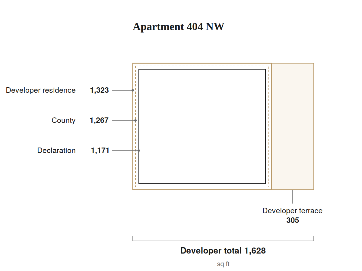
Floor plan of apartment 404 NW with the three measurement boundaries drawn and the terrace shown separately. All four figures are in the table below.

MLS listings on this line publish 1,267 square feet on every floor: 8.2% above what the declaration records for the fourth floor. Between this apartment’s smallest and largest figure, 1,171 and 1,628, there is 39%.

Why there are four figures

Every Oceana floor plan the developer published carries the same footnote:

“Stated dimensions are measured to the exterior boundaries of the exterior walls and the centerline of interior demising walls and in fact vary from the dimensions that would be determined by using the description and definition of the ‘Unit’ set forth in the Declaration (which generally only includes the interior airspace between the perimeter walls and excludes interior structural components). For the square footage of the ‘Unit’ calculated in the manner set forth in the Declaration, see Exhibit ‘3’ to the Declaration.”

This page is that instruction, carried out.

Exhibit 3 lists all 240 apartments and their recorded areas, one by one. It was recorded on 17 November 2016 as part of the Second Amendment to the Declaration of Oceana Bal Harbour Condominium, the substantial completion amendment, which replaced the original Exhibit 3 in its entirety. It records the building as completed.

The 240 rows of Exhibit 3 total 652,458 square feet, exactly. The document states 100.0000% of the common elements as its total; adding the 240 percentages, each rounded to four decimal places, gives 100.0001%. The difference is the rounding, not the document.

The exact square-foot total is what makes any single row checkable against the whole: an apartment’s area divided by 652,458 gives its percentage to four decimal places. I checked all 240 rows, with no exceptions.

The 01 line shows the distance between the two documents in one figure. The declaration records it at 3,992 square feet. The developer’s floor plan book publishes 4,185 for the same apartment, 4.83% more. The two figures describe the same space measured two ways, and the developer says so in the footnote on every plan.

Below, for every apartment: the area recorded in the declaration, the area the county carries, the residence and terrace areas the developer published, and the folio.

They do not all agree.

Of the 240, four have no separate county record and four more are recorded jointly with a neighbour, which leaves 232 that can be compared one to one. On 32 of those the county holds a different figure from the declaration — 24 larger, 8 smaller.

These are the same four apartments seen from both sides: where the county records two apartments under one folio, the other is left with no record of its own.

On 238 of 238 the developer’s figure is larger, which is what the developer’s own footnote says to expect: the plans measure to the outside of the exterior wall and the centre of the dividing wall, and the declaration measures the interior airspace.

The terrace is a fourth figure. The MLS has no field for it.

#404 and #1104 are both published at 1,267 square feet. One of them is 1,171.

The MLS publishes all four, mixed together

None of the four figures is false. They measure different things, and taking the square footage from the developer’s material is standard practice across the industry: publishing one figure per line is a normal shortcut. What follows is not a complaint about anyone. It is a count of which figure the buyer is reading.

Of the 126 transactions in the record, 124 published a square footage. In twelve of those the apartment cannot be determined, so the published figure cannot be compared with anything. The remaining 112:

The MLS figure is…Transactions
the area recorded in the declaration66
the residence figure from the developer’s book28
the county’s figure15
residence plus terrace0
none of the four3

Two notes on the count. “The county’s figure” means the MLS figure equals the county’s where the county differs from the declaration; where the two agree, 200 of 232 apartments, the transaction is counted under the declaration, because that test runs first. And the zero is not a rounding: in ten years, no listing has published residence plus terrace.

The same apartment, two figures. Unit 1701 in the south tower was published at 3,992 square feet in 2020 and at 4,185 in 2023. Unit 701 in the north tower was published at 3,992 in 2021 and at 4,185 in 2026. The declaration records 3,992 for both, in all four listings.

A whole line, one figure. Of the seven listings on the 04NW and 04SW plan, five published 1,267 square feet: the same number on the fourth floor as on the eleventh. On the eleventh that is the recorded figure. On the fourth the declaration says 1,171. Of the other two, one published 1,285 and the other covers two apartments sold as one.

And there is a fourth source. At least one listing states that the area was supplied by the owner rather than by a document. 502 is the clearest case: it was published at 2,130 square feet in one listing, the developer’s residence figure, and at 2,140 in another, which corresponds to no document.

Before comparing two apartments in this building, what you need to know is which of the four figures you are reading for each one.

All 240 apartments

The residence and terrace columns carry the developer’s own figures, and each one links to the plan for its line on the Oceana Bal Harbour floor plan page, which reproduces the original plan book. That is where every link in this table goes: the plan the figure comes from.

Unit Declaration County Developer residence Developer terrace Developer total
1001 N3,9923,992 12-2226-050-00404,1851,5955,780
1001 S3,9923,992 12-2226-050-03304,1851,5955,780
1002 NE-M2,1212,121 12-2226-050-06702,2334252,658
1002 SE-M2,1212,121 12-2226-050-09102,2334252,658
1003 NE-M1,5761,576 12-2226-050-11401,6323551,987
1003 SE-M1,5181,518 12-2226-050-13701,5813551,936
1004 NW1,2671,267 12-2226-050-16101,3233051,628
1004 SW1,2671,267 12-2226-050-17201,3233051,628
1005 NW1,7041,704 12-2226-050-18201,7784652,243
1005 SW1,7041,704 12-2226-050-19201,7784652,243
1006 E2,5312,531 12-2226-050-19802,6254453,070
1101 N3,9923,992 12-2226-050-00504,1851,5955,780
1101 S3,9923,992 12-2226-050-03404,1851,5955,780
1102 NE-M2,1212,121 12-2226-050-06802,2334252,658
1102 SE-M2,1212,121 12-2226-050-09202,2334252,658
1103 NE-M1,5761,576 12-2226-050-11501,6323551,987
1103 SE-M1,5181,518 12-2226-050-13801,5813551,936
1104 NW1,2671,267 12-2226-050-16201,3233051,628
1104 SW1,2671,267 12-2226-050-17301,3233051,628
1105 NW1,7041,704 12-2226-050-18301,7784652,243
1105 SW1,7041,704 12-2226-050-19301,7784652,243
1106 E2,5312,531 12-2226-050-19902,6254453,070
1107 W2,2332,233 12-2226-050-21802,2964452,741
1201 N3,9923,992 12-2226-050-00604,1851,5955,780
1201 S3,9923,992 12-2226-050-03504,1851,5955,780
1202 NE-M2,1102,110 12-2226-050-06902,2334252,658
1202 SE-M2,1102,110 12-2226-050-09302,2334252,658
1203 NE-M1,5761,576 12-2226-050-11601,6323551,987
1203 SE-M1,5181,518 12-2226-050-13901,5813551,936
1204 NW1,2671,267 12-2226-050-16301,3233051,628
1204 SW1,2671,267 12-2226-050-17401,3233051,628
1205 NW1,7041,704 12-2226-050-18401,7784652,243
1205 SW1,7041,704 12-2226-050-19401,7784652,243
1206 E2,5262,526 12-2226-050-20002,6254453,070
1207 W2,2262,226 12-2226-050-21902,2964452,741
1401 N3,9923,992 12-2226-050-00704,1851,5955,780
1401 S3,9923,992 12-2226-050-03604,1851,5955,780
1402 N3,4503,450 12-2226-050-07003,5927454,337
1402 S3,4503,450 12-2226-050-09403,5927454,337
1403 N3,3453,345 12-2226-050-11703,6077904,397
1403 S3,2643,264 12-2226-050-14003,4087904,198
1406 E2,5262,526 12-2226-050-20102,6254453,070
1407 W2,2262,226 12-2226-050-22002,2964452,741
1501 N3,9923,992 12-2226-050-00804,1851,5955,780
1501 S3,9923,992 12-2226-050-03704,1851,5955,780
1502 N3,4503,450 12-2226-050-07103,5927454,337
1502 S3,4503,450 12-2226-050-09503,5927454,337
1503 N3,4643,464 12-2226-050-11803,6077904,397
1503 S3,2643,264 12-2226-050-14103,4087904,198
1506 E2,5262,526 12-2226-050-20202,6254453,070
1507 W2,2262,226 12-2226-050-22102,2964452,741
1601 N3,9923,992 12-2226-050-00904,1851,5955,780
1601 S3,9923,992 12-2226-050-03804,1851,5955,780
1602 N3,4503,450 12-2226-050-07203,5927454,337
1602 S3,4503,450 12-2226-050-09603,5927454,337
1603 N3,4643,464 12-2226-050-11903,6077904,397
1603 S3,2643,264 12-2226-050-14203,4087904,198
1606 E2,5262,526 12-2226-050-20302,6254453,070
1607 W2,2262,226 12-2226-050-22202,2964452,741
1701 N3,9923,992 12-2226-050-01004,1851,5955,780
1701 S3,9923,992 12-2226-050-03904,1851,5955,780
1702 N3,4503,450 12-2226-050-07303,5927454,337
1702 S3,450county — not recorded separately; shares folio 12-2226-050-1430 with 1703 S3,5927454,337
1703 N3,4643,464 12-2226-050-12003,6077904,397
1703 S3,264county — one folio covering two joined apartments, 3,264 + 3,450 12-2226-050-14303,4087904,198
1706 E2,5262,526 12-2226-050-20402,6254453,070
1707 W2,2262,226 12-2226-050-22302,2964452,741
1801 N3,9923,992 12-2226-050-01104,1851,5955,780
1801 S3,9923,992 12-2226-050-04004,1851,5955,780
1802 N3,4503,450 12-2226-050-07403,5927454,337
1802 S3,4503,450 12-2226-050-09803,5927454,337
1803 N3,4643,464 12-2226-050-12103,6077904,397
1803 S3,2643,264 12-2226-050-14403,4087904,198
1806 E2,5262,526 12-2226-050-20502,6254453,070
1807 W2,2262,226 12-2226-050-22402,2964452,741
1901 N3,9923,992 12-2226-050-01204,1851,5955,780
1901 S3,9923,992 12-2226-050-04104,1851,5955,780
1902 N3,4503,450 12-2226-050-07503,5927454,337
1902 S3,4503,450 12-2226-050-09903,5927454,337
1903 N3,4643,464 12-2226-050-12203,6077904,397
1903 S3,2643,264 12-2226-050-14503,4087904,198
1906 E2,5262,526 12-2226-050-20602,6254453,070
1907 W2,2262,226 12-2226-050-22502,2964452,741
2001 N3,992county — one folio covering two joined apartments, 3,992 + 3,450 12-2226-050-01304,1851,5955,780
2001 S3,9923,992 12-2226-050-04204,1851,5955,780
2002 N3,450county — not recorded separately; shares folio 12-2226-050-0130 with 2001 N3,5927454,337
2002 S3,4503,450 12-2226-050-10003,5927454,337
2003 N3,4643,464 12-2226-050-12303,6077904,397
2003 S3,2643,264 12-2226-050-14603,4087904,198
2006 E2,5262,526 12-2226-050-20702,6254453,070
2007 W2,2262,226 12-2226-050-22602,2964452,741
201 NE2,1492,149 12-2226-050-02002,2688003,068
201 NW1,7991,805 12-2226-050-02501,9177952,712
201 SE2,1482,148 12-2226-050-04902,2688003,068
201 SW1,8051,805 12-2226-050-05401,9177952,712
202 NE-M2,1142,114 12-2226-050-05902,2334252,658
202 SE-M2,1142,114 12-2226-050-08302,2334252,658
204 N1,7521,752 12-2226-050-1530not statednot statednot stated
204 S1,7521,752 12-2226-050-1640not statednot statednot stated
2101 N3,9923,992 12-2226-050-01404,1851,5955,780
2101 S3,992county — one folio covering two joined apartments, 3,992 + 3,450 12-2226-050-04304,1851,5955,780
2102 N3,4503,450 12-2226-050-07703,5927454,337
2102 S3,450county — not recorded separately; shares folio 12-2226-050-0430 with 2101 S3,5927454,337
2103 N3,4643,464 12-2226-050-12403,6077904,397
2103 S3,2643,264 12-2226-050-14703,4087904,198
2106 E2,5262,526 12-2226-050-20802,6254453,070
2107 W2,2262,226 12-2226-050-22702,2964452,741
2201 N3,9923,992 12-2226-050-01504,1851,5955,780
2201 S3,9923,992 12-2226-050-04404,1851,5955,780
2202 N3,4503,450 12-2226-050-07803,5927454,337
2202 S3,4503,450 12-2226-050-10203,5927454,337
2203 N3,4643,464 12-2226-050-12503,6077904,397
2203 S3,2643,264 12-2226-050-14803,4087904,198
2206 E2,5262,526 12-2226-050-20902,6254453,070
2207 W2,2262,233 12-2226-050-22802,2964452,741
2301 N3,9923,992 12-2226-050-01604,1851,5955,780
2301 S3,9923,992 12-2226-050-04504,1851,5955,780
2302 N3,4503,450 12-2226-050-07903,5927454,337
2302 S3,4503,450 12-2226-050-10303,5927454,337
2303 N3,4643,464 12-2226-050-12603,6077904,397
2303 S3,2643,264 12-2226-050-14903,4087904,198
2306 E2,5262,526 12-2226-050-21002,6254453,070
2307 W2,2262,233 12-2226-050-22902,2964452,741
2401 N3,9923,992 12-2226-050-01704,1851,5955,780
2401 S3,9923,992 12-2226-050-04604,1851,5955,780
2402 N3,4503,450 12-2226-050-08003,5927454,337
2402 S3,4503,450 12-2226-050-10403,5927454,337
2403 N3,4643,464 12-2226-050-12703,6077904,397
2403 S3,2643,264 12-2226-050-15003,4087904,198
2406 E2,5262,526 12-2226-050-21102,6254453,070
2407 W2,2262,233 12-2226-050-23002,2964452,741
2501 N3,9923,992 12-2226-050-01804,1851,5955,780
2501 S3,9923,992 12-2226-050-04704,1851,5955,780
2502 N3,4503,450 12-2226-050-08103,5927454,337
2502 S3,4503,450 12-2226-050-10503,5927454,337
2503 N3,4643,464 12-2226-050-12803,6077904,397
2503 S3,2643,264 12-2226-050-15103,4087904,198
2506 E2,5262,526 12-2226-050-21202,6254453,070
2507 W2,2262,233 12-2226-050-23102,2964452,741
2601 N3,9923,992 12-2226-050-01904,1851,5955,780
2601 S3,9923,992 12-2226-050-04804,1851,5955,780
2602 N3,4503,450 12-2226-050-08203,5927454,337
2602 S3,4503,450 12-2226-050-10603,5927454,337
2603 N3,4643,464 12-2226-050-12903,6077904,397
2603 S3,2643,264 12-2226-050-15203,4087904,198
2606 E2,5262,526 12-2226-050-21302,6254453,070
2607 W2,2262,233 12-2226-050-23202,2964452,741
301 NE2,1482,148 12-2226-050-02102,2688003,068
301 NW1,8051,805 12-2226-050-02601,9177952,712
301 SE2,1482,148 12-2226-050-05002,2688003,068
301 SW1,8051,805 12-2226-050-05501,9177952,712
302 NE2,0192,019 12-2226-050-06002,1304252,555
302 SE2,0192,019 12-2226-050-08402,1304252,555
303 NE1,5131,513 12-2226-050-10701,6033551,958
303 SE1,4591,459 12-2226-050-13001,5493551,904
304 NW1,1711,267 12-2226-050-15401,3233051,628
304 SW1,1711,267 12-2226-050-16501,3233051,628
305 NW1,7071,704 12-2226-050-17501,7784652,243
305 SW1,7071,704 12-2226-050-18501,7784652,243
401 NE2,1482,148 12-2226-050-02202,2688003,068
401 NW1,8051,805 12-2226-050-02701,9177952,712
401 SE2,148county — one folio covering two joined apartments, 2,148 + 1,805 12-2226-050-05102,2688003,068
401 SW1,805county — not recorded separately; shares folio 12-2226-050-0510 with 401 SE1,9177952,712
402 NE2,0192,019 12-2226-050-06102,1304252,555
402 SE2,0192,019 12-2226-050-08502,1304252,555
403 NE1,5131,513 12-2226-050-10801,6033551,958
403 SE1,4591,459 12-2226-050-13101,5493551,904
404 NW1,1711,267 12-2226-050-15501,3233051,628
404 SW1,1711,267 12-2226-050-16601,3233051,628
405 NW1,7071,704 12-2226-050-17601,7784652,243
405 SW1,7071,704 12-2226-050-18601,7784652,243
501 NE2,1482,148 12-2226-050-02302,2688003,068
501 NW1,8051,805 12-2226-050-02801,9177952,712
501 SE2,1482,148 12-2226-050-05202,2688003,068
501 SW1,8051,805 12-2226-050-05701,9177952,712
502 NE2,0192,019 12-2226-050-06202,1304252,555
502 SE2,0192,019 12-2226-050-08602,1304252,555
503 NE1,5131,513 12-2226-050-10901,6033551,958
503 SE1,4591,459 12-2226-050-13201,5493551,904
504 NW1,1711,267 12-2226-050-15601,3233051,628
504 SW1,1711,267 12-2226-050-16701,3233051,628
505 NW1,7071,704 12-2226-050-17701,7784652,243
505 SW1,7071,704 12-2226-050-18701,7784652,243
601 NE2,1482,148 12-2226-050-02402,2688003,068
601 NW1,8051,805 12-2226-050-02901,9177952,712
601 SE2,1482,148 12-2226-050-05302,2688003,068
601 SW1,8051,805 12-2226-050-05801,9177952,712
602 NE2,0212,019 12-2226-050-06302,1304252,555
602 SE2,0212,019 12-2226-050-08702,1304252,555
603 NE1,4951,513 12-2226-050-11001,6033551,958
603 SE1,4421,459 12-2226-050-13301,5493551,904
604 NW1,2571,267 12-2226-050-15701,3233051,628
604 SW1,2571,267 12-2226-050-16801,3233051,628
605 NW1,6901,704 12-2226-050-17801,7784652,243
605 SW1,6901,704 12-2226-050-18801,7784652,243
701 N3,9923,992 12-2226-050-00104,1851,5955,780
701 S3,9923,992 12-2226-050-03004,1851,5955,780
702 NE-M2,1212,121 12-2226-050-06402,2334252,658
702 SE-M2,1212,121 12-2226-050-08802,2334252,658
703 NE-M1,5761,576 12-2226-050-11101,6323551,987
703 SE-M1,5181,518 12-2226-050-13401,5813551,936
704 NW1,2561,267 12-2226-050-15801,3233051,628
704 SW1,2561,267 12-2226-050-16901,3233051,628
705 NW1,7041,704 12-2226-050-17901,7784652,243
705 SW1,7041,704 12-2226-050-18901,7784652,243
706 E2,5312,531 12-2226-050-19502,6254453,070
707 W2,2332,233 12-2226-050-21402,2964452,741
801 N3,9923,992 12-2226-050-00204,1851,5955,780
801 S3,9923,992 12-2226-050-03104,1851,5955,780
802 NE-M2,1212,121 12-2226-050-06502,2334252,658
802 SE-M2,1212,121 12-2226-050-08902,2334252,658
803 NE-M1,5761,576 12-2226-050-11201,6323551,987
803 SE-M1,5181,518 12-2226-050-13501,5813551,936
804 NW1,2561,267 12-2226-050-15901,3233051,628
804 SW1,2561,267 12-2226-050-17001,3233051,628
805 NW1,7041,704 12-2226-050-18001,7784652,243
805 SW1,7041,704 12-2226-050-19001,7784652,243
806 E2,5312,531 12-2226-050-19602,6254453,070
807 W2,2332,233 12-2226-050-21502,2964452,741
901 N3,9923,992 12-2226-050-00304,1851,5955,780
901 S3,9923,992 12-2226-050-03204,1851,5955,780
902 NE-M2,1212,121 12-2226-050-06602,2334252,658
902 SE-M2,1212,121 12-2226-050-09002,2334252,658
903 NE-M1,5761,576 12-2226-050-11301,6323551,987
903 SE-M1,5181,518 12-2226-050-13601,5813551,936
904 NW1,2561,267 12-2226-050-16001,3233051,628
904 SW1,2561,267 12-2226-050-17101,3233051,628
905 NW1,7041,704 12-2226-050-18101,7784652,243
905 SW1,7041,704 12-2226-050-19101,7784652,243
906 E2,5312,531 12-2226-050-19702,6254453,070
1007 W2,2332,233 12-2226-050-21702,2964452,741
907 W2,2332,233 12-2226-050-21602,2964452,741
PH 2701N7,5347,534 12-2226-050-23307,7742,33510,109
PH 2701S7,5347,534 12-2226-050-23407,7742,33510,109
PH 2702N5,9185,918 12-2226-050-23506,1111,2407,351
PH 2702S5,6205,620 12-2226-050-23605,9041,2407,144
UPH-2802E5,8545,854 12-2226-050-23906,1454,95711,102
UPH-2801N8,9938,993 12-2226-050-23709,3719,95019,321
UPH-2801S8,9318,931 12-2226-050-23809,3719,95019,321
UPH-2802W4,9774,977 12-2226-050-24005,1835,19310,376

Sources and method

Figures as of 9 October 2026.

Declaration areas: Exhibit 3, CFN 2016R0665037. County areas: Miami-Dade Property Appraiser, by folio. Residence and terrace areas: the Oceana Bal Harbour plan book, published by the developer.

Where the county records two joined apartments under a single folio, or does not record an apartment separately, the cell says so rather than showing a figure.

Exhibit 3 was recorded as scanned pages and carries no searchable text. The 240 rows above were read from the page images and checked three ways: the row count against the declaration’s stated 240, the area total against its stated 652,458, and every apartment’s ownership percentage against its own area. All three reconcile.

I did that because I represent buyers and sellers in this building, and I was not prepared to quote an apartment a figure I had not read myself. Once the table existed there was no reason to keep it to myself.

Exhibit 3 to the Second Amendment to the Declaration of Oceana Bal Harbour Condominium, CFN 2016R0665037, OR Book 30312, Pages 332–388, recorded 17 November 2016. Verified current — no subsequent amendment restates Exhibit 3 (Third Amendment, CFN 2017R0264036, adds only the Cabana Club). The complete 57-page instrument as recorded is reproduced here.

What these apartments have asked and what they received is in the sale record.

The figures in this table cover Oceana Bal Harbour only. The Oceana Bal Harbour building page collects everything published about the property.

If your apartment is one of the thirty-two the county holds differently, or one of the four it does not record separately, ask me what that means for pricing. The answer is the same whether or not you ever list.

Alerts for this building

What closes here, and notice when something moves, on-market or off. Name a line if you have one, or leave it blank for the whole building.

Register a Line